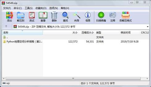
资源简介

代码片段和文件信息
“““SimpleGIS.py - A Simple GIS“““

import turtle as t

# DATA MODEL
# All layers will have a name 1+ points and population count
NAME = 0
POINTS = 1
POP = 2

# Create the state layer
state = [“COLORADO“ [[-109 37] [-109 41] [-102 41] [-102 37]] 5187582]

# Cities layer list
# city = [name [point] population]
cities = []

# Add Denver
cities.append([“DENVER“ [-104.98 39.74] 634265])
# Add Boulder
cities.append([“BOULDER“ [-105.27 40.02] 98889])
# Add Durango
cities.append([“DURANGO“ [-107.88 37.28] 17069])

# MAP GRAPHICS RENDERING
map_width = 800
map_height = 500

# State Bounding Box
# Use Python min/max function to get bounding box
minx = 180
maxx = -180
miny = 90
maxy = -90
for x y in state[POINTS]:
    if x < minx:
        minx = x
    elif x > maxx:
        maxx = x
    if y < miny:
        miny = y
    elif y > maxy:
        maxy = y

# Get earth distance on each axis
dist_x = maxx - minx
dist_y = maxy - miny

# Scaling ratio each axis
# to map points from world to screen
x_ratio = map_width / dist_x
y_ratio = map_height / dist_y


def convert(point):
    “““Convert lat/lon to screen coordinates“““
    lon = point[0]
    lat = point[1]
    x = map_width - ((maxx - lon) * x_ratio)
    y = map_height - ((maxy - lat) * y_ratio)
    # Python turtle graphics start in the middle of the screen
    # so we must offset the points so they are centered
    x = x - (map_width/2)
    y = y - (map_height/2)
    return [x y]

# Add a title to the window
wn = t.Screen()
wn.title(“Simple GIS“)

# Draw the state
t.up()
first_pixel = None

for point in state[POINTS]:
    pixel = convert(point)
    if not first_pixel:
        first_pixel = pixel
    t.goto(pixel)
    t.down()
# Go back to the first point
t.goto(first_pixel)
# Label the state
t.up()
t.goto([0 0])
t.write(state[NAME] align=“center“ font=(“Arial“ 16 “bold“))

# Draw the cities
for city in cities:
    pixel = convert(city[POINTS])
    t.up()
    t.goto(pixel)
    # Place a point for the city
    t.dot(10)
    # Label the city
    t.write(city[NAME] + “ Pop.: “ + str(city[POP]) align=“left“)
    t.up()

# Perform an attribute query
# Question: Which city has the largest population?
# Write the result but make sure it‘s under the map
biggest_city = max(cities key=lambda city: city[POP])
t.goto(0 -1*((map_height/2)+20))
t.write(“The highest-populated city is: “ + biggest_city[NAME])

# Perform a spatial query
# Question: Which is the western most city?
# Write the result but make sure it‘s under the other question
western_city = min(cities key=lambda city: city[POINTS])
t.goto(0 -1*((map_height/2)+40))
t.write(“The western-most city is: “ + western_city[NAME])

# Hide our map pen
t.pen(shown=False)
t.done()
属性 大小 日期 时间 名称
----------- --------- ---------- ----- ----
目录 0 2019-07-18 09:28 Python地理空间分析指南(第2版)源代码\
目录 0 2019-07-18 09:28 Python地理空间分析指南(第2版)源代码\B04606_01_Code\
文件 2852 2015-02-24 17:24 Python地理空间分析指南(第2版)源代码\B04606_01_Code\B04606_01_01_SimpleGIS.py
目录 0 2019-07-18 09:28 Python地理空间分析指南(第2版)源代码\B04606_02_Code\
文件 665 2015-02-25 05:17 Python地理空间分析指南(第2版)源代码\B04606_02_Code\B04606_02_01_structDemo.py
文件 5015 2015-04-24 05:33 Python地理空间分析指南(第2版)源代码\B04606_02_Code\B04606_02_02_fmtDecode.py
文件 360 2015-04-23 12:12 Python地理空间分析指南(第2版)源代码\B04606_02_Code\B04606_02_03_GeoJSON.py
目录 0 2019-07-18 09:28 Python地理空间分析指南(第2版)源代码\B04606_04_Code\
文件 168 2015-06-01 06:03 Python地理空间分析指南(第2版)源代码\B04606_04_Code\B04606_04_01-site-packages.py
文件 236 2015-06-02 05:50 Python地理空间分析指南(第2版)源代码\B04606_04_Code\B04606_04_02-urlretrieve.py
文件 379 2015-06-02 06:31 Python地理空间分析指南(第2版)源代码\B04606_04_Code\B04606_04_03-earthquake-data.py
文件 402 2015-06-01 06:03 Python地理空间分析指南(第2版)源代码\B04606_04_Code\B04606_04_04-ftp.py
文件 434 2015-06-01 07:13 Python地理空间分析指南(第2版)源代码\B04606_04_Code\B04606_04_05-ftp-url.py
文件 488 2015-06-02 05:50 Python地理空间分析指南(第2版)源代码\B04606_04_Code\B04606_04_06-zipfile.py
文件 321 2015-06-02 05:50 Python地理空间分析指南(第2版)源代码\B04606_04_Code\B04606_04_07-zipfile-loop.py
文件 258 2015-06-02 05:49 Python地理空间分析指南(第2版)源代码\B04606_04_Code\B04606_04_08-tarfile-create.py
文件 218 2015-06-02 05:49 Python地理空间分析指南(第2版)源代码\B04606_04_Code\B04606_04_09-tarfile-extract.py
文件 465 2015-06-02 05:48 Python地理空间分析指南(第2版)源代码\B04606_04_Code\B04606_04_10-cloud-zipfile.py
文件 736 2015-06-02 05:47 Python地理空间分析指南(第2版)源代码\B04606_04_Code\B04606_04_11-kml-minidom.py
文件 372 2015-06-02 06:55 Python地理空间分析指南(第2版)源代码\B04606_04_Code\B04606_04_12-kml-etree.py
文件 488 2015-06-02 05:45 Python地理空间分析指南(第2版)源代码\B04606_04_Code\B04606_04_13-make-kml-strings.py
文件 693 2015-06-02 06:56 Python地理空间分析指南(第2版)源代码\B04606_04_Code\B04606_04_14-make-kml-etree.py
文件 482 2015-06-02 05:38 Python地理空间分析指南(第2版)源代码\B04606_04_Code\B04606_04_15-gpx-soup.py
文件 160 2015-06-01 06:03 Python地理空间分析指南(第2版)源代码\B04606_04_Code\B04606_04_16-shapely-wkt.py
文件 418 2015-06-02 00:09 Python地理空间分析指南(第2版)源代码\B04606_04_Code\B04606_04_17-ogr-wkt.py
文件 556 2015-06-01 06:51 Python地理空间分析指南(第2版)源代码\B04606_04_Code\B04606_04_18-json.py
文件 257 2015-06-01 06:24 Python地理空间分析指南(第2版)源代码\B04606_04_Code\B04606_04_19-geojson.py
文件 374 2015-06-02 05:37 Python地理空间分析指南(第2版)源代码\B04606_04_Code\B04606_04_20-ogr.py
文件 286 2015-06-02 05:37 Python地理空间分析指南(第2版)源代码\B04606_04_Code\B04606_04_21-pyshp.py
文件 337 2015-06-02 05:36 Python地理空间分析指南(第2版)源代码\B04606_04_Code\B04606_04_22-dbfpy.py
文件 202 2015-06-01 06:03 Python地理空间分析指南(第2版)源代码\B04606_04_Code\B04606_04_23-shapely.py
............此处省略72个文件信息
- 上一篇:Python爬取房价信息
- 下一篇:Flow blog数据库课程设计
相关资源
- python+ selenium教程
- PycURL(Windows7/Win32)Python2.7安装包 P
- 英文原版-Scientific Computing with Python
- 7.图像风格迁移 基于深度学习 pyt
- 基于Python的学生管理系统
- A Byte of Python(简明Python教程)(第
- Python实例174946
- Python 人脸识别
- Python 人事管理系统
- 基于python-flask的个人博客系统
- 计算机视觉应用开发流程
- python 调用sftp断点续传文件
- python socket游戏
- 基于Python爬虫爬取天气预报信息
- python函数编程和讲解
- Python开发的个人博客
- 基于python的三层神经网络模型搭建
- python实现自动操作windows应用
- python人脸识别(opencv)
- python 绘图(方形、线条、圆形)
- python疫情卡UN管控
- python 连连看小游戏源码
- 基于PyQt5的视频播放器设计
- 一个简单的python爬虫
- csv文件行列转换python实现代码
- Python操作Mysql教程手册
- Python Machine Learning Case Studies
- python获取硬件信息
- 量化交易(附python常见函数的使用方
- python 名字用字排行
 川公网安备 51152502000135号
评论
共有 条评论